 This is Nepal's biggest river, it carries the most water and the highest sediment load. It used to be called the 'Sorrow of Bihar' because the Kosi often changed course, bringing misery to millions of people downstream in India.
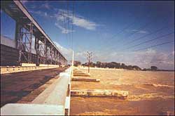
 In 1964, India built the Kosi Barrage (see pic) near the border to control the floods and to provide irrigation to farms in both countries. But standing atop of one of the towers looking out at this sea-like expanse of water, it is clear the Kosi is a river that is about to go places.
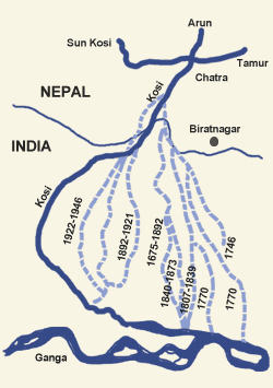
The gray-brown river surges out of the mountains of eastern Nepal to join the Ganga in India, depositing some 120 million cubic metres of silt along the basin every year-twice as much as the Nile and five times more than the Sutlej. The river is now flowing several metres above the surrounding land, and only slender embankments in Nepal and Bihar keep the mighty river in check.
Near the barrage the Kosi turns into a delta, with islands and vegetation sprouting from long sand bars. Below us, the flood gates are raised to their maximum height to let the monsoon waters through, but there is only 30cm between the steel gates and accumulated sediment.
This week, the water flow is 200,000 cubic metres per second (cusec). Alarm bells rang last month when the flow reached 400,000 cusecs and the flood waters nearly topped the barrage. Sedimentation has raised the river bed by three metres, and even during a normal monsoon the barrage is in danger.
Experts now fear a mammoth flood, like the 800,000 cusec discharge in 1968, that could sweep away the barrage itself, unleashing devastating floods in Nepal and India. Because the river bed has been raised by sediment, even a 500,000 cusec flood, similar to the one that came down in 1987, could threaten the barrage. Since then the sediment has choked the river even more.
Upstream from the barrage in Nepal, there are two 12km and 32km embankments on either side of the Kosi that channel the river towards the sluice gates. Over the years, the rising waters has scoured these earth embankments. There is also water seepage through the levees into the fields and villages on the other side.
The Kosi has migrated 150km westwards since 1730, and now flows along a channel it made in the 1954 flood. At the point where the river flows out of the mountains in Chatara, the Kosi is riding higher and experts fear it could easily flow back to its original course. This would take it past the heavily-populated farms on the eastern outskirts of Biratnagar and down across the Bihar and West Bengal plains. Such a flood would be of such proportions that everything else in the history of the Kosi would pale in comparison.
"Various studies on the Kosi have shown this to be a very real possibility, and it would cause an unimaginable human catastrophe. We would all be caught napping." says Nepali water resources expert, AB Thapa.
Just 15km upstream, the Sunkosi, Tamur and Arun join to form the mighty Sapta Kosi that cuts a deep gash in the mountains before disgorging into the plains. Others share Thapa's concern for Chatara as the possible trouble spot. If the Kosi's tributaries in eastern Nepal all peak at the same time during an above-normal late monsoon cloudburst when the soil is already saturated, the river could easily change course at Chatara.
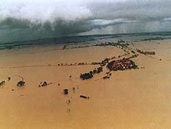 None of the experts we talked to could accurately estimate the casualty figures if the Kosi changed course, by-passing the barrage altogether. The estimates ranged from 1-10 million people affected in Nepal and India with tens of thousands of deaths, and longterm destruction to crops and livelihood. "Anything could happen," says Ajaya Dixit of the Nepal Water Conservation Foundation. "This is a very unpredictable river."
 The Indian government's reaction to the annual floods in Bihar has been to repeat its commitment to build a mammoth 269m high dam at Barachhetra, the Kosi's gorge 15km upstream from Chatara. The dam has been proposed since 1947 and the only reason it hasn't been built is because of cost, and the lack of priority for Bihar within India. But things seem to be moving. There was an initial understanding with Nepal in 1992 to study the site. And news in mid-June that this year's floods were threatening the barrage came coincidentally on the same day as a report that a joint Nepal-India team was setting up a feasibility study on the Kosi High Dam.
The Nepali side has never objected to the Kosi High Dam, but only wants that its future project-to transfer Sun Kosi storage water to the tarai through tunnels-not be affected by the dam. The joint study is expected to look at both projects in conjunction. The three-year $10 million study would look at the feasibility of what could be the largest hydroelectric and irrigation project in the region costing anywhere up to $3 billion. "It all depends on that study if we will really build the dam," says Surendra Mahananda Bajracharya of the Department of Electricity Development.
Indian officialdom is all out to push the idea of the Kosi High Dam, presenting it as a project not just to protect the barrage but also as a longterm flood control and energy solution for Nepal and northern India. "The high dam will actually prove to be beneficial for Nepal," officials of the Bihar Department of Irrigation stationed at the Kosi Barrage told us this week. There are indications that India now wants to prioritise Kosi, since the other joint projects on Pancheswor and Mahakali have turned out to be political hot potatoes in Nepal.
Indians engineers argue that the Kosi High Dam would check downstream flow of silt which means the river bed will stop rising, thus prolonging the life of the barrage. There would be flood control benefits, water released in the dry season would help irrigation and generate 4,000 megawatt of power that Nepal could sell to India. Another bonus is the possibility of a regulated Kosi providing Nepali goods access to the sea through river navigation, Indian officials say.
Some Nepali experts, however, caution that the plans are too grandiose and will not solve the problem of sedimentation. "Because of the Kosi's huge sediment load, the dam will silt up just like the barrage has silted up," says water expert Santa Bahadur Pun. Bihar sees the high dam as a panacea for all its ills, but it could turn out to be a white elephant.
Bajracharya at the Department of Electricity Development disagrees, arguing that the sedimentation problem can be mitigated. "We cannot compare the Kosi Barrage and the Kosi High Dam because they are based on different technologies. The barrage cannot clear accumulated sediment, while there are now new technologies to flush sediment from dam reservoirs."
 For India, the Kosi High Dam project could be a component of its super-ambitious $2 trillion project to interlink 37 Indian rivers for flood control and irrigation. According to recent reports in the Indian press, the Kosi will be linked by canal to the Ghagara, and similar links will be made between the Gandaki, Karnali and Mahakali river systems after they flow out of Nepal. The waters of the Gandaki for instance, will be channeled to the Ganga so that waters from flood prone areas reach drought-hit places.
 The Nepal government has not been officially notified about the river linking project and what role, if any, Nepal may be asked to play. But it is clear that since at least six of the 37 rivers originate in Nepal, there will have to be some kind of reliance on storage dams in the Himalaya.
However, there is disagreement within India about the interlinking project-between states and between the BJP government and environmental activists. (See: 'Conjoined rivers', #156). By the time the feasibility study for the Kosi High Dam is complete in 2007, and if construction starts, it will take at least till 2012 before it is finished.
The question is will the Kosi Barrage have been washed off by then? Or worse, will the Kosi have changed course at Chatara in the next 15 years? Both would be disasters with huge human costs and an economic and political fallout. But the disasters could also sway public opinion in Nepal and India in support of a longterm solution to Kosi floods, like a high dam.
AB Thapa is in favour of launching the Sun Kosi storage and diversion project at Kurule, north of Chatara before the high dam. "One benefit would be to help us control the Kosi from jumping toward Biratnagar," says Thapa, formerly of the Water and Energy Commission. The Ministry of Water Resources would prefer to wait for the feasibility study, since a future Kosi reservoir would submerge the Sun Kosi diversion if it is built earlier.
Given the experience of Panchswor, it is clear that much more water has to flow down the Kosi before the debate about the high-dam is resolved and the necessary political will garnered. The debate over the Kosi is nothing new, it was a question that bedevilled even British engineers who were entrusted with trying to tame the 'Sorrow of Bihar' in the 19th century.
"British engineers were divided about dams and embankments for flood control," says Ajaya Dixit. "Today, looking at the sedimentation problems at the Kosi Barrage we have to admit that they were talking sense."
Whatever the case, the threats of a Kosi breach at Chatara or a flood bypass of the barrage are clear and present dangers. It could happen 10 years from now, or it could happen next week. But it will happen. And when it does it will make this year's floods and landslides look like a picnic.

