 Days 1, 2, 3 and 4.
 Fly Pokhara-Jomsom (2,710 m) and the next day reach Muktinath (3,760 m). Climb the dramatic Dzong Dadaa (5,200 m) that towers north of Muktinath. Tough going with no clear path to the top and great views towards Upper Mustang. Next day ascend Thorung La pass (5,416 m) and then head east and down, overnighting in the dramatic surroundings of Thorung Phedi.
Day 5.
Down to Manang village (3,540 m) with my mind on the challenge of crossing back over the Annapurna massif to Jomsom via Tilicho (lake). Accounts of this trip warn of difficult route finding and inaccurate maps.
Day 6.
Not feeling too well but 'the thing that drives me' starts to rumble. I buy a walking stick for the treacherous scree slopes ahead and head for Khangsar village.
I find the keeper of Tilicho Base Camp Lodge. He agrees to open the lodge. He promises to follow me out there and points out the way-an improbable-looking route across some distant steep scree slopes. Beginning to feel good as my engine engages. Climbing and climbing and taking in the amazing wild landscape of snow peaks, forests, whitewater streams and anticipating the challenge ahead.
 What was driving me on was the prospect of the beautiful wild landscapes and the need to push my limits now and again. I am not suicidal but like a challenge. "Never trek alone!"."Take a guide as the route is arduous and difficult to find"."Only climb 300 m a day over 3000 m altitude!" You can set aside this sensible advice if you know what you are doing, are fit and the conditions are favourable.
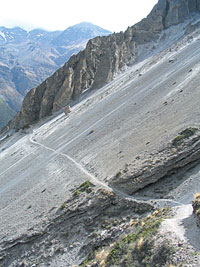
 What a fantastic trail through huge scree slopes and along cliff sides. I linger taking in the wilderness atmosphere and the precipitous drops as the lodge keeper catches up with me. We pass scarecrows designed to keep snow leopards away.
Day 7.
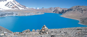
The next morning's pull up to the lake is tough. There is 800 m of lung-bursting altitude to climb with my rucksack feeling like it's full of boulders. I cross the rim and.what a sight.a huge expanse of azure water surrounded by rock, snow and ice.
It is 11AM as I set off towards the other end of the lake. I take the safe route the long way round the eastern side over two high passes. I am slowing down and have to push myself forward. Passing a few blue sheep I soon reach the first 5,240 m pass. The path then peters out and from here the going gets really tough for the next, somewhat challenging, 24 hours.
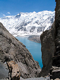
I navigate along the side of a melting glacier to the Eastern Pass (5,340 m). Terrific views of the lake framed by a cliff-sided gully.
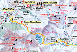
At 4.15 PM I lift myself up and set off towards Meso Kanta La (5,121 m) along the large lateral moraines. I make good progress but keep losing the path as I follow the suggested route from the Internet round the north of a shark-toothed peak. I plod on at a pace of about 30 steps and then a minute's rest.
At 6PM I reach the saddle and look into the valley leading towards Jomsom. The gusting wind and the late hour stop me from lingering. The next part is supposed to be pretty treacherous and so I quickly head down what is the wrong steep scree and boulder-filled gully. A few large stones whiz past. I keep to the side thankful for my 25-rupee stick to negotiate the patches of steep snow and ice.
 I feel relief from the drop in altitude (4,700 m). Now it is a question of finding the route. I can't make sense of the map and am convinced it is wrong. Anyway, I am heading in roughly the right direction and losing altitude but the indistinct tracks show no human footprints. I have in my mind the need to avoid the risky prospect of stumbling into the army's high-altitude warfare training camp below Nilgiri in the half light.
 Heading further northwest and down I reach the treeline. I keep going by the light of the half moon and at 8PM, stop at a level patch of dusty ground and spread my sleeping bag out for the night.
Day 8.
I don't get much sleep worrying about a leopard leaping on me. Somehow feel quite rested as I set off at 5.30 AM the next morning. I head down into a ravine clambering through wild forest.
Below I try to work my way downstream but soon find my way barred by a waterfall with no way around. I then head back upstream and pass what looks like a fresh bear footprint on a boulder. I then try to climb out the opposite side up some slatey scree and cliffs thinking that if I come across a bear's den with cubs I'll be a goner.
Near the top it gets too risky and I painstakingly pick my way back down. Finally I manage to clamber up the northeast side of the ravine reaching more level ground at about 11AM with great relief. After crossing another ravine I reach a good path and a few hours later, pace into Jomsom feeling relieved and quite exhilarated but puzzled about my route-finding difficulties.
The next morning sitting in Pokhara airport waiting for the connection to Kathmandu I take another look at the map. I laugh out loud as it suddenly makes sense. I pick out the meandering route across the contours I had taken the day before and realise that the Internet route photo was wrong and had sent me to the wrong side of the shark tooth peak. Next time I'm going for a beach holiday in Thailand, although the time after that I'll be back in the hills.
 Route
Route The first part of the route follows the Annapurna Circuit in a clockwise direction from Jomsom to Manang village. Most people do the circuit anti-clockwise partly to avoid having to climb the Thorung La pass from the Muktinath side as it involves 1,700 m of ascent.
Quite a number of trekkers reach Tilicho from Manang as an acclimatisation trip with at Tilicho Base Camp Lodge on the way. Very few make the trip over to Jomsom from Tilicho and it does help if you know the right way!


