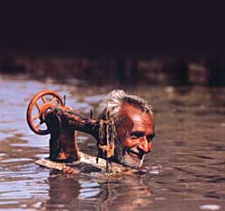
 The monsoon has become a predictable annual tragedy. Yet, every year, hundreds of Nepalis die and tens of thousands are displaced due to floods, especially in the tarai. This year's rainy season is only half over, but already more than 150 people have lost their lives.
 Still, there is no monitoring of rainfall in the mountains and midhills to provide early warning that rivers may overflow their banks in the plains. Flood forecasting in Nepal is non-existent. There is little forecasting in India or Bangladesh either. Billions are spent on flood relief and building embankments, but there is no money for prevention and early warning.
In fact, forecasting in Nepal would help downstream countries to analyse data and predict river levels in the Ganga and in the Bangladesh delta where millions are marooned by annual floods. Organisations for regional cooperation exist: ICIMOD, SAARC and both are headquartered in Nepal.
Officials at the Department of Water Induced Disaster Management say that if only there was a timely warning system it could save hundreds of lives and property worth millions of rupees every year, adding, "At present, we help build embankments and other structures to save people in flood-prone areas. But if there was an early forecasting system, we could streamline it."
Of Nepal's four major river systems, the most risky is the Kosi and its tributaries, which could bring devastation next time it changes its course as it has been doing for centuries. Experts fear that the river, with heavy sedimentation, could jump from Chatara washing off thousands of villages on its path in Nepal and north Bihar.
It is difficult to predict the weather, but it is relatively simple to measure rain once it has fallen and process the information quickly enough for early warning to vulnerable areas. "Monitoring rivers at the upper reaches would certainly increase lead time for forecasting the floods in the plain," says Naba Raj Adhikari, an official at the Department of Hydrology and Meteorology.
But the hurdles are funding, lack of expertise and equipment. There are presently 43 hydrological stations across the country to measure rainfall and the flow of rivers, but data is sent in from these stations only once every 24 hours, if at all. Some of that information is sent on to India for analysis and no one knows what happens to the data there.
"Flood forecasting is just not happening," admits senior hydrologist Kehsab Prasad Sharma at the Department of Hydrology and Meteorology. "We have no technical capability and institutional back up for flood forecasting." Department officials say they need real time data on rainfall, river volume and even a process to calculate snow melt based on temperature readings.
Last year, the department successfully tested a pilot project on the Narayani River by setting up a station to record
and send flow data on an hourly basis to Kathmandu with radio transmitters. The test was a success, but Sharma notes, "To improve the system we need more investment and there is no budget."
The main cost involved would be in transmission of data via satellite for central processing. Nepali officials have now been pushing the idea of regional forecasting which would benefit Nepal and the other countries in the region. But other than occasional meetings over the past two years the work hasn't moved ahead.
Professor Qin Dahe of the China Meteorological Administration and the Cold Arid Regions Environment Research Institute says collecting real time data in catchment areas of the region is vital: "The data can be transmitted to different hydrological centres of the countries in the region through a regional communication system."
Data from China would help forecasting floods in Assam, for instance. Professor Dulal C Goswami of Guwahati University says, "There is immense possibility for regional co-operation with regard to flood management including flood forecasting and warning. All we need to do is start working at it."
ICIMOD and the UN's World Meteorological Organisation have organised two consultations on flood forecasting in the last three years to develop a report on regional flood information system. Under this plan, a pilot project for preparing a regional framework should begin next year and continue until 2008.
Larger countries in the region, like India and China, prefer to do things bilaterally with their neighbours. But floods affect all the countries, and officials say it is narrow-minded to want to do things only one-on-one. Says Sharma: "India and China are interested in doing things bilaterally and it is working for them, but it is the smaller countries like ours who need regional forecasting and don't have our own resources."


