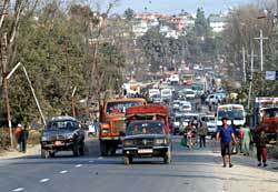
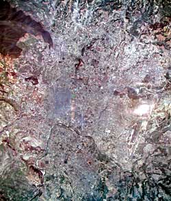
 The residents of Kathmandu see it every day: a city straining to cope with urbanisation. Unplanned settlements, water shortage, overcrowded streets, air and water pollution have all but wiped out a Valley once known for the harmony of its architecture and fertility of its land. Indeed, Kathmandu Valley's unique heritage is derived from this rural-urban symbiosis.
 This has been taken into account in numerous urban development plans in the past 35 years, starting with the 1969 Kathmandu Valley Physical Development Plan. The challenge has always been to translate the plans into reality. In 2000, the IUCN's Kathmandu 2020 study tried to address the issue of urban sprawl and how to contain it. The government has strongly backed the containment policy and advocates densification of already settled areas of the Valley contained in that report.
Containment keeps the population within given boundaries and controls urban sprawl. In Kathmandu Valley it makes sense because land resource is limited and there has been unplanned growth in the past. Since the cost of infrastructure is high and there is a need to sustain the Valley's ecological balance, Kathmandu 2020 proposed to keep at least 300 persons per hectare (ppha) population density with optimal 500 ppha.
According to the 2001 Census only the city core of Kathmandu has a density of more than 500 ppha. In the rest of the metro area, population density is 150 ppha or below but there is alarming growth rate in the outlying VDCs. Out of the 20 urbanising VDCs 10 have population growth rates higher than six percent per year. Kapan scores highest with 12.12 percent, Jorpati has 13.41 and Gonga Bu has 13.46 percent.
In its 20-year plan, Kathmandu 2020 wanted to limit the builtup and non-builtup ratio of land use to 40:60 by 2021, which is the accepted upper limit for ecological balance. By 2001 this ratio had already topped 32:68. The result: fragmentation of land, narrow and meandering access roads, no attention paid to drainage and slopes, and no consideration of land suitability which is turning the Valley into a huge slum.
Kathmandu 2020 tried to address the problem by introducing a rural-urban boundary to be maintained by improving roads, water, power, phones and sewages in already developed areas and restricting development in the agricultural zones by not providing infrastructure. The gazetted document states: '.the provision of regional trunk infrastructures such as highway or arterial road, drinking water.need to be consistent with the goals of compact urban form, so they don't help further urban sprawl.'
 In hindsight, many planners believe that premature construction of the existing Ring Road in 1983 was one of the main causes of haphazard urban sprawl in the Valley. In the absence of a connecting road network and other infrastructure, the Ring Road has been overrun by construction. Not a single major link road has been added after the Ring Road was built. A road designed as an arterial access (with average vehicular speeds of 80 kmph) is compelled to cater to all types of vehicles and can hardly average 30 kmph.
 In 1993, the Japanese aid group JICA made an extensive transportation study of Kathmandu Valley. Building on land use and other strategic plans it suggested several short, medium and longterm remedies. One was for a part of the Outer Ring Road to link Budhanilkantha-Thimi-Lubhu-Bungmati since the existing Ring Road does not cover the eastern end of the Valley. There were other short term and medium term proposals and almost none of them were implemented.
The Outer Ring Road proposal to be built with a Chinese grant is considerably different from the JICA alignment. There are questions that need to be answered about its feasibility given the land use, traffic load, economic viability and how it fits with the urban containment strategy.
The preliminary map appearing in the media of the Outer Ring Road running along the foothills of the Valley rim does not show strong justification. Worse, this is a supply side management approach and completely ignores the Kathmandu 2020 urban-rural divide to ensure the Valley's balanced growth.
We need an Outer Ring Road but not now. Also, the proposed alignment ignores the Kathmandu 2020 strategy plan and would seriously threaten the future ecological balance of the Valley. Then there is the question of priority: given the state of the country does the capital deserve yet another free infrastructure?
Politicians like to bequeath large projects to the country as a legacy of their tenure. But such desires must match overall strategies and national priorities. The tragedy of Kathmandu's planning is that it has historically been used by politicians and betrayed by experts.
There are two options to go with this road project: switch from an outer ring road to an inner ring road following corridors along the Dhobi Khola, Bagmati, Bishnumati and in the northern part of the Sorhakhutte-Handigaon link to meet Dhobikhola. This decision would be perfectly in line with the Ministry of Physical Planning and Works and the Kathmandu 2020 containment policy. It will also be easy to implement since the preliminery design work on three sides have already been completed.
The second option demands strong political commitment: bring the whole Kathmandu Valley (at least the area encircled by the proposed Outer Ring Road) under planned development. It will be a challenge but with our experience in land pooling, be possible with nominal investment from the government. Taking the Outer Ring Road as an opportunity, there should be political commitment not to allow land in Kathmandu Valley for construction without designated infrastructure. Strict enforcement would ensure that the Kathmandu 2020 urban rural boundary proposal is respected. Municipalities and VDCs could then plan and manage growth.
The key challenge is the lack of political commitment. Land is valuable in this vertical country and being the capital it is even more scarce and precious. Any intervention that undermines land use would be suicidal. We can stop repeating mistakes, learn from them and not blunder again by going for an Outer Ring Road for all the wrong reasons.
Click for the proposed Ring Road map
Padma Sunder Joshi used to be with the Planning Unit of the Kathmandu Metropolitan City and is now a lecturer at the Institute of Engineering.


