 DINESH SHRESTHA/MILAP DIXIT 30,000 YEARS AGO: This panorama by Dinesh Shrestha, taken from Lakuri Bhanjyang in 2008, was manipulated to visualise what the Kathmandu Valley must have looked like when it was a huge lake. |
 DINESH SHRESTHA |
Kathmandu Valley is where mythology and geology intertwine. The former holds that the Tibetan saint, Manjushree, flew down to Kathmandu. Upon seeing the huge lake, he cut the Chobhar ridge in half with his mighty sword and drained the waters to allow civilisation to flourish in the fertile sacred valley.
There is ample geological evidence to prove that the Kathmandu Valley was once a lake. But geologists piecing together the genesis and demise of the primordial lake now think it may not have been drained all at once, but in phases.
The lake was formed over one million years ago with the tectonic uplift of the southern edge of the Valley and the damming up of the proto-Bagmati River, probably where Katuwal Daha is today. As the southern rim of the Valley rose at a geologically rapid 3cm a year, the lake shifted northwards. The level of the lake ebbed and rose between 1,400-1,440m, depending on the prevailing climate, making it about 200m deep in places.
Geologists have found the fossil remains of the extinct ancestors of mammoths, hippos and crocodiles in the Kathmandu Valley. They have pollen-dated the sediment, indicating that the shoreline of the Kathmandu Lake was heavily forested with pine and hemlock and teeming with wildlife.
The last Ice Age cooled and dried the Himalaya and the lake started to shrink starting 30,000 years ago. The main water body carved its way through the soft limestone at Chobhar, leaving behind a shrinking lake and three smaller ones at Gokarna, Pashupati and Kitni. These lakes later carved 'mini-Chobhars' and emptied into the main lake.
As the lake receded, flats emerged above the water that were later separated by the tributaries of the Bagmati, which sliced channels through the soft clay. The airport is one such flat from the Gokarna Period 30,000 years ago, and geologists think Thimi and Patan surfaced 25,000 and 18,000 years ago respectively.
The Kathmandu Valley civilisation with Lichhavi and and then Newar settlements grew and prospered because of the fertility of the soil, and later because of the Valley's location along the ancient trade route between India and Tibet. In their wisdom the early settlers set up towns along ridgelines, leaving the fertile slopes for farms. This unique urban-rural symbiosis and the agricultural surplus it resulted in enriched the kingdoms of the Valley, and they ploughed back the wealth into the unique cultural and architectural heritage of their towns.
Kunda Dixit
The rise and fall
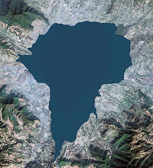
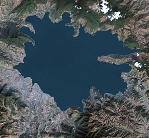
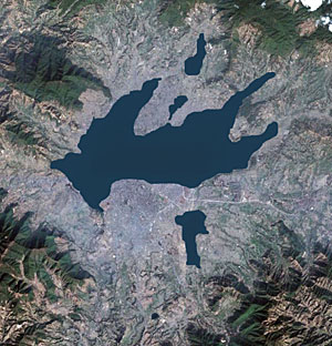
Approximate extension of the proto-Kathmandu Lake overlaid on a current Google Earth image of the valley. The shoreline of the lake is loosely based on a composite of geological studies by Japanese and Nepali experts, and may not correspond to contemporary contours because of tectonic uplift in the last 100,000 years.
 120,000 years ago Upliftment of the southern edge of what is now Lalitpur district and blockage of the proto-Bagmati river at present-day Katuwal Daha, leading to the impounding of water in the Kathmandu basin. |
 30,000 years ago Continued tilting of the Kathmandu basin moves the lake towards the north and the lake level, blocked by the Chobhar ridge, is at its maximum height of 1,440m. Bhaktapur, Patan, Manohara Valley and Gokarna are all under water. |
 15,000 years ago Climate change and seepage through rocks at Chobhar lower the level of the water, exposing the Gokarna, Thimi and Gauchar (present-day airport) flats, and leaving three smaller lakes behind bedrock ridges at Gokarna, Pashupati and Kitni. |
READ ALSO:
Stuff Nepali People Like - I
Take me to the river
Snakebite!, DHANVANTARI by BUDDHA BASNYAT, MD


