|
|
It may still be too early to draw definite conclusions on the crash of a Shree Airlines MI-17 near Ghunsa last week with the tragic loss of lives.
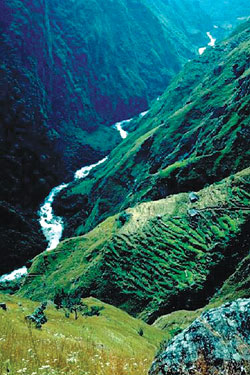
But given reports of heavy rains and rough terrain there are reasons to suspect CFIT-that familiar and ominous acronym that has made Nepal the country with one of the worst air safety records in the world.
Controlled Flight into Terrain is the technical terminology for an aircraft flying into a mountain in bad weather. Of the 15 fatal crashes in Nepal since 1992 with the loss of 320 lives, 12 were CFIT.
To be sure, flying in the Himalaya is difficult even in the best weather conditions: with tricky, ill-equipped airports, lack of navigational beacons, and turbulence. When you mix clouds with mountains, the situation becomes exponentially more risky. "Flying in Nepal in the monsoon, there is one thing we always tell junior pilots: avoid clouds, they have rocks in them," says one trainer pilot with Nepal Airlines.
Even experienced pilots find flying in the Himalaya a challenge. The army pilot who set a world record by landing his EADS Ecureuil on the Western Cwm on a mountaineering rescue in 1996 crashed his B2, a chopper modified for high altitude performance, at Everest Base Camp. In May this year, an MI-8 trying to take off from Dhaulagiri Base Camp with eight climbers on board had to make a hard landing. All escaped miraculously. "Taking a helicopter to a mountain is more dangerous than climbing it," said one mountaineer in a blog post. There have been four chopper crashes at Everest Base Camp alone and two more have crashed en route in the past five years.
Over-confidence can also be a reason when pilots rely too much on the Global Positioning System, which draws a straight line to the destination without taking terrain into account during white-outs. There is a tendency not to circulate inquiry reports from past accidents and therefore failure to learn from mistakes.
Terrain warning systems are not mandatory in Nepal, and even when they are installed in the cockpit, the audio warnings tend to be ignored because pilots are always flying close to mountains. There is Enhanced Ground Proximity Warning (EGPW) equipment available, which integrates a satellite-based 3D topographic image of the route and warns pilots of mountains ahead even when obscured by cloud. But these can cost upto $100,000.
Even if EGPW one day became mandatory on aircraft flying within Nepal, the Civil Aviation Authority has to ask what do we do till then. If the weather was as bad as the met office said it was last Saturday, the MI-17 had no business being in Ghunsa. This is a narrow valley and the helipad itself at 4,300m. At the time of takeoff, it was surrounded by swirling mist.
Whether the chopper went down because of loss of control due to turbulence caused by up-valley catabatic winds or hit a cloud-covered mountainside is now academic. The inquiry commission must not just answer what happened, it must also have recommendations on how to prevent similar accidents in future.
Can we have new Instrument Flying Rule (IFR) thresholds for safe flying in high mountain areas? Should we leave private and charter flying in remote areas in bad weather just to pilot discretion? We must also have better navaids in remote area airports. If a crash does happen, aircraft must have satellite tracking devices so we don't see a repeat of an aircraft disappearing without trace for four days. The fact that an Asian Airlines MI-17 that disappeared on a flight from Makalu Base Camp to Lukla carrying porters from a French Makalu Expedition in June 2002 has still not been found shows us that flying in Nepal needs much more stringent rules than those in other countries.

