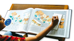
 A picture is worth a thousand words and this is also true of the newly published Population and Socio-economic Atlas of Nepal.
 With 210 maps on 10 different themes related to social, economic and demographic indicators, the atlas offers graphic versions of data from the 2001 census, dissecting Nepal into cross-sections viewed through a host of parameters.
Want to know where Chepang-speaking people live in Nepal? Which districts have the most disabled people? Where is the sex-ratio most glaring? How does Kathmandu's migrant population compare with Chitwan's? Where are the most young people living? Which districts are the farthest behind in girl enrolment? Where are the female-headed households?
Find all the answers in these clear, colourful and illuminating maps that put the data at your fingertips. "All it takes is one glance to see the density of population in Kathmandu and how the rest is distributed over the country," says Suresh M Shrestha from the government-run National Geographic Information Infrastructure Programme (NGIIP) implemented by the Survey Department.
Shrestha and his small team of GIS experts, cartographers, statisticians and demographers worked hard to make the atlas of international quality, developing new software to ensure perfection in all technical inputs.
"The atlas will be a very useful tool for geographers, development planners, policy makers and researchers," says Shrestha, who believes the project is the first of its kind in the country. Jointly conceived and produced by the Survey Department and Central Bureau of Statistics (CBS) with support from the EU, the main objective was to present demographic socio-economic indicators based on the last census. Since socio-economic indicators have changed rapidly because of internal displacement and other effects of the conflict in the past four years, some of the data could be outdated today. Also, there is a puzzling lack of data and parameters for Kalikot and Sallyan.
In 2003, ICIMOD and Dutch aid group SNV published a similar atlas with the same 2001 census data, which was a lot less bulky and also carried a trend analysis of district-by-district figures from previous censuses that allowed comparisons of how socio-economic indicators were changing over time. (See: 'A time atlas of Nepal', #185) To be sure, this atlas makes comparisons between the 1991 and 2001 censuses for male and female literacy but it could have done that for more parameters.
The atlas carries a mine of data and some of the maps stand out to remind readers which ethnic groups are concentrated in certain areas of the country. It even includes the population of non-Nepali origin like the Sikhs and Marwaris. This atlas will tell you that Brahmins and Chettris make up the largest segment of the poplulation and also where they live.
The Population and Socio-economic Atlas of Nepal
HMG Survey Department and Central Bureau of Statistics
Kathmandu 2004
Rs 2,500

