 Maps are static. They show the world flat, as it is. But what if you wanted to see Nepal's progress in development, or lack thereof? And suppose you wanted that segregated by district? Information in both time and space.
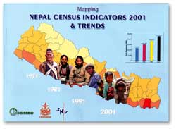
 That is exactly what the recently published Mapping Nepal Census Indicators 2001 and Trends has done. Brought out by ICIMOD, the Central Bureau of Statistics (CBS) and the Dutch aid group, SNV, the book plots census data from 1971, 1981, 1991 and 2001, and divides them by district. The maps mean more than just which districts are ahead in schooling for girls, infant health, fertility rate, etc. They also show how much progress each district has made and which ones are lagging behind.
The beauty of it is that you can make these trends out at a glance, without having to pore through pages and pages of figures. And because the districts are colour-coded, the achievements and failures of development at the grassroots over the past 30 years leap out of the page. The problem then, is to figure out what to do about them.
The book was released recently without much fanfare, but deserves much more attention than it has hitherto been given. The study team was lead by ICIMOD's Basanta Shrestha and Rabi Prasad Kayastha of CBS, and used geographical information system techniques to produce the thematic maps that represent trends to enable rapid and visual grasp of the implications for the country of individual development parameters. The book will soon be followed by a CD-ROM that will enable planners and local development officials to segregate the data by thematic areas, districts and timeline.
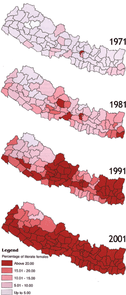
Percentage of literate females
 Starting from relatively straightforward mapping of district-wise trends in population density, the atlas shows us how fast the tarai is being filled. The eastern tarai, for instance, used to have a population density of 200-400 per sq km. By 2001, that figure had jumped to 400-800 per sq km. Kathmandu Valley's density has now crossed the 800 per sq km mark.
 The average population growth rate used to be above 4 percent in the eastern tarai in the 1970s. Today it is at an average of 2.5 percent despite migration-related growth. Ilam even shows less than 2 percent population growth and, correlating this with the trends in progress in female literacy, it becomes clear why this is so.
Sex ratio (the number of males for every 100 females) is an important indicator of the status of women within a society. This atlas shows a clear correlation between gender equity and other parameters such as girl's literacy, maternal mortality and fertility rates. It is clear that the worst sex ratio is in the east-central tarai districts of Rautahat, Sarlahi and Mahottari where the number of males for every 100 females has remained above 105 since 1971. The second worst are the Midwestern districts of Achham, Bajura, Bajhang and Dailekh.
The mean age of marriage of women shows that in the eastern hills, Mustang and Manang are far ahead of the rest of the country with 22 years or above. But girls are still getting married at ages between 16-18 in the east-central tarai and the midwestern hills and this mean age hasn't improved much.
Female literacy rates show the most sluggish progress in the midwestern and far-western hills and east-central tarai in the past 30 years, and hint at the neglect of development that has contributed to the rise of the insurgency. Similarly, the midwestern hills show the least progress in enrollment in schools.
[email protected]
www.icimod.org, www.cbs.gov.np

